
Instrumentations
UAS
Recently, UAV (unmanned aerial vehicle) technology has improved rapidly.
ideaSky constructed an UAS (Unmanned Aircraft System) network, FALCON (Facility of Aerial Low-Cost Observational Network), possessing self-developed low-level atmospheric UAV sounding system. Developing vertical profile monitoring technology helps understand the three-dimensional distribution of pollutants and their vertical transport, and assesses how boundary layer development affects surface air quality.
Instrument Introduction
360 V4
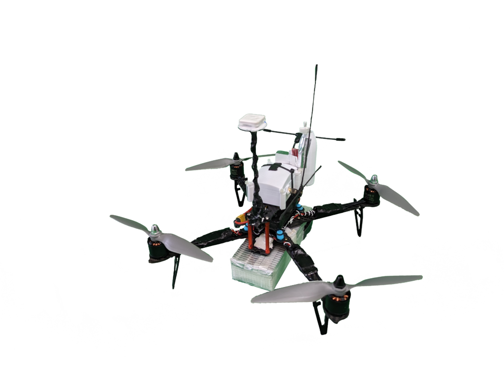
| Drone Type | Quadcopter |
| Material | Carbon-fiber reinforced polymer |
| Power Source | Li-Po |
| Maximum Load | < 1 kg |
| Endurance | 20 – 30 minutes |
| Maximum Flight Altitude | 3 km |
| Flight Speed | 3 – 4 ms-1 |
| Maximum Takeoff Weight | 2 kg |
850 V6
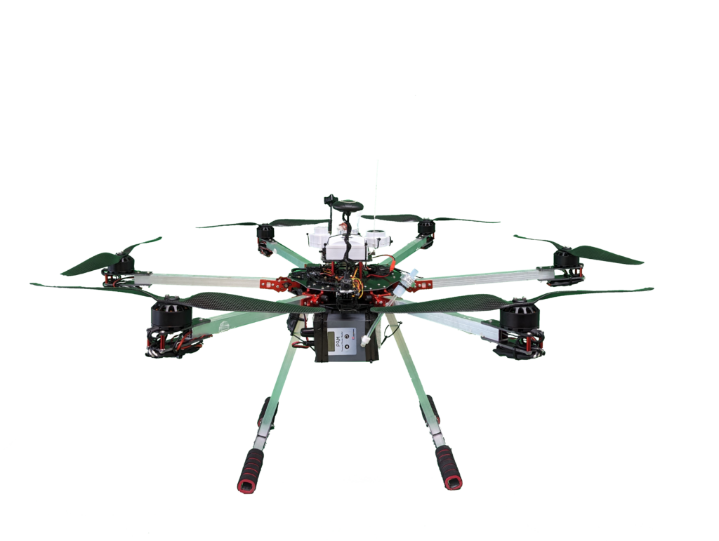
| Drone Type | Hexacopter |
| Material | Aerospace Grade Aluminum |
| Power Source | Li-Po |
| Maximum Load | 2 kg |
| Endurance | 20 – 30 minutes |
| Maximum Flight Altitude | 1.5 km |
| Flight Speed | 3 – 4 ms-1 |
| Maximum Takeoff Weight | 6.5 kg |
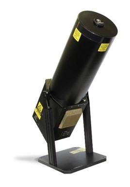
MPL System & Sun photometer
The Micro-Pulse Lidar (MPL) System is an active ground-based remote sensing technique that provides the aerosol characteristics in vertical structure through the Normalized Relative Backscattering (NRB) and Depolarization Ratio, representing the aerosol relative concentration and particle symmetries. The high temporal and spatial resolutions help detect the height of the cloud base, the air pollutant distribution, and its movement; the aerosol vertical profiles further apply to atmospheric boundary layer height determination.
The sun photometer is a passive ground-based remote sensing instrument that automatically tracks solar, lunar, and sky. It measures different wavelengths, directions, and time periods of visible and near-infrared. It provides the aerosol optical characteristics in the total column including Aerosol Optical Depth (AOD), Ångström exponent (AE), Single Scattering Albedo (SSA), and so on. Also, the cloud mode activates as soon as the cloud covers the sun to retrieve the Cloud Optical Depth (COD) value.
Micro pulse lidars and Sun-photometers, provide the aerosol optical characteristics in vertical distribution and the total column, respectively. To understand the air quality issue, these two instrumentations are helpful and comprehensive equipment.
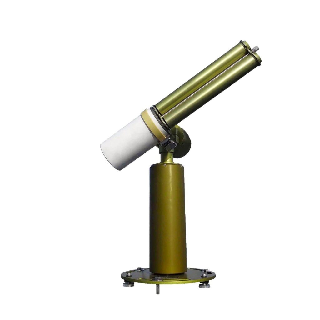
Micro-Pulse Lidar (MPL) System
Micro-Pulse Lidar (MPL) System includes a coaxial transmit/receive telescope, a ferroelectric liquid crystal (FLC) as the depolarizer for depolarizing, a laser head with a wavelength of 532 nm doubled frequency by solid crystal Nd:YAG, and a laptop with data collection software. An additional wide FOV receiver (WFR) be set up on the reference instrument.
MPL provides continuous observation with high temporal and spatial resolution for the vertical structure of low atmosphere. It transmits a laser beam and receives the backscattering signals by a laser pulse. The light backscattered by molecules and aerosols is detected and analyzed to determine the relative aerosol concentration vertical distribution in the atmosphere through the parameter of Normalized Relative Backscattering (NRB).
The depolarization ratio from MPL observation represents the particle symmetries that facilitate the distinction between dust aerosols, biomass burning aerosols, fire events plumes, or anthropogenic aerosols thereby significantly enhancing the efficacy of air quality monitoring.
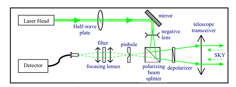
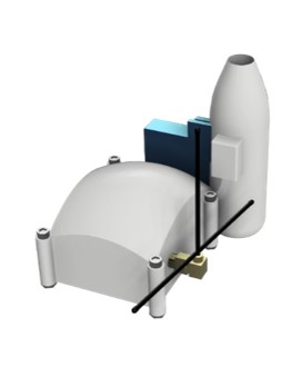
Basic configuration of MPL
(retrieved from: https://opg.optica.org/oe/fulltext.cfm?uri=oe-15-6-2785&id=131136)
NASA MPLNET (NASA Micro Pulse lidar Network)
The NASA Micro-Pulse Lidar Network (MPLNET) is a federated network of Micro-Pulse Lidar (MPL) systems designed to measure aerosol and cloud vertical structure, and boundary layer heights. The data are collected continuously, day and night, over long time periods from sites around the world.
Learn more about MPLNETTaiwan MPL Network
Observing the aerosol optical characteristics in the vertical direction by using remote sensing techniques, which can monitor the change of pollutants over time and space, is complementary for air quality monitoring.
Learn more about Taiwan MPL NetworkSun photometer
The sun photometer measures different wavelength, direction, time period of visible and near-infrared light of sun and sky to infer the characteristics of atmospheric components such as aerosols, water vapor, and ozone. It automatically tracks sun and lunar, and also provides optional cloud mode that activates as soon as the cloud covers the sun. The cloud mode uses optical band of 400nm and 870nm to retrieve the Cloud Optical Depth (COD) value
All the sun photometers belong to ideaSky has joined the AERONET and provides real-time data.
The sun photometer is a passive ground-based remote sensing instrument that automatically tracks solar, lunar, and sky. It measures different wavelengths, directions, and time periods of visible and near-infrared. It provides the aerosol optical characteristics in the total column including Aerosol Optical Depth (AOD), Ångström exponent (AE), Single Scattering Albedo (SSA), and so on. Also, the cloud mode activates as soon as the cloud covers the sun to retrieve the Cloud Optical Depth (COD) value.
AERONET (Aerosol Robotic Network)
The AERONET (Aerosol Robotic Network) program is a federation of ground-based remote sensing aerosol networks established by NASA and PHOTONS. It is greatly expanded by networks and collaborators from national agencies, institutes, universities, individual scientists, and partners.
For more than 25 years, the project has provided long-term, continuous, and readily accessible public domain database of aerosol optical, microphysical and radiative properties for aerosol research and characterization, validation of satellite retrievals, and synergism with other databases. The network imposes standardization of instruments, calibration, processing and distribution.
Learn more about AERONETAPAC (Asia Pacific AERONET Calibration and Training Center)
Taiwan’s Ministry of Environment and NASA have a history of cooperation of 20 years. With this long history of collaboration, NASA cooperated with the Lulin Atmospheric Background Station (LABS) to establish a calibration platform at Mt. Lulin. In 2023, the Asia Pacific AERONET Calibration and Training Center, APAC was established as the major AERONET calibration center in Asia.
Learn more about APACInstrument Introduction
Lab Development
ideaSky has self-developed a series of instruments to both enhance the efficiency and reduce the costs of atmospheric observations, while also effectively filling the data gaps in current environmental monitoring studies. We are continuously dedicated to driving innovation at the cutting edge.
Instrument Introduction
| Drone | |
| Mate | Carbon |
| P | Li |
| Max | 1 kg |
| Endurance | 20 – 30 minutes |
| Maximum Flight Altitude | 3 km |
| Flight Speed | 3 – 4 ms⁻¹ |
| Maximum Takeoff Weight | 2 kg |
| Drone Type | Quadcopter |
| Material | Carbon-fiber reinforced polymer |
| Power Source | Li-Po |
| Maximum Load | < 1 kg |
| Endurance | 20 – 30 minutes |
| Maximum Flight Altitud | 3 km |
| Flight Speed | 3 – 4 ms-1 |
| Maximum Takeoff Weight | 2 kg |
| Drone Type | Quadcopter |
| Material | Carbon-fiber reinforced polymer |
| Power Source | Li-Po |
| Maximum Load | < 1 kg |
| Endurance | 20 – 30 minutes |
| Maximum Flight Altitud | 3 km |
| Flight Speed | 3 – 4 ms-1 |
| Maximum Takeoff Weight | 2 kg |